Tlaqna Farfara?! Ancient Maps Of Malta Depicting A ‘Phantom Island’ To The South Are Going Viral

Which Maltese island is your favourite? Usually, it’s a tough call between the quieter Gozo and the utopian Comino, with tiny Filfla getting some underdog love. But what if I told you there was once another island throw in the mix?
Earlier this week, a heated and very intriguing debate raged on Maltese Facebook forums, and it took readers back a couple of centuries.
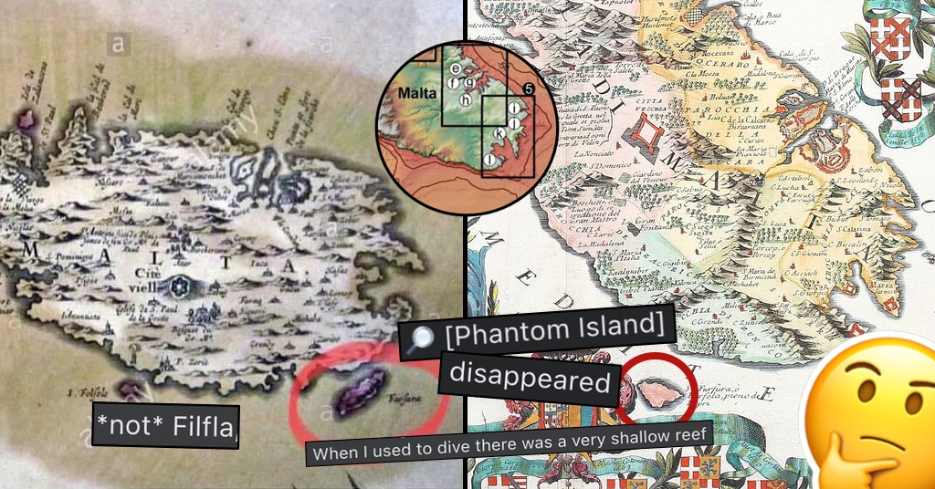
In some of the earliest maps of Malta from the 16th century, people started noticing a weird, sizeable “mystery island” just to the south of the mainland, simply named “Farfara”.
At first, going off the usual inaccuracies of such maps, people were quick to dismiss it as an ancient misspelling and misplacement of Filfla… until they realised that island was already accounted for.
Another map shows the large Farfara even more prominently…
But with Filfla not showing in this one and the mystery island being labelled Forfola, it might not be the most reliable map to base your theories on.

And while the original post led to days worth of heated debates on history and geology, here’s what we know…
First of all, errors in old maps are not unheard of. You just need to take half a glance at the map above to realise something’s off, and that’s down to the simple fact that maps then were either drawn aboard a ship circling the island, or worse yet, from the particular cartographer’s memory.
Speaking of the fickle nature of memory and hearsay, you’d have a 1680s map depicting Farfara… but a map from a hundred years before calling it Folfola – which we know is Filfla.
Also, let’s not forget that this was a time where empty spaces on the world map would be filled in with random islands or sea monsters… so there’s that.
However, it looks like there’s more to this story…
“It seems that there used to be an islet called Farfara for a very short period of time.” one user said after some more research. “Modern geologists hypothesize that it was some temporary vulcanic sand or other type of temporary islet created. It quickly eroded and disappeared and now there is very little evidence of it remaining on the bedrock of the sea. It was uninhabited.”
“It wasn’t mentioned much because of the short time span when it was visible.”
Other divers and fishers soon joined the conversation, saying they’ve come across a very shallow reef in the area around Bengħajsa, pointing at a possible location of the long-lost islet. Hurd’s Bank, a shallow body of water in front of the Freeport, was also a contender in the list.
Whatever the truth is, though, we would’ve loved to have had another Maltese island to visit… even if it would probably end up being overcrowded or developed within a decade or two.